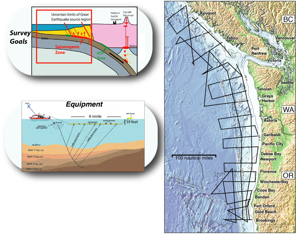
Scientific Objectives
At the Cascadia Subduction Zone, the slow ongoing descent of the Juan de Fuca plate beneath the northwestern coast of North America has generated large earthquakes (EQ) and associated tsunami in the past. Geologic records suggest that some sections of the subduction zone fault or “megathrust”, which extends ~35-90 miles seaward from the coasts of northern California all the way to southern British Columbia, slipped less than other sections during the last large earthquake (1700 AD), and that in some prior EQ only parts of the subduction zone ruptured. Whether these along-margin variations may persist in future EQ has important implications for quantifying earthquake and tsunami hazards within the heavily populated Pacific Northwest margin. Geologic structure such as seamounts and other topographic features in the descending Juan de Fuca plate, the structure and properties of the thick folded and faulted package of sediments that forms above the subduction zone fault, or the properties of megathrust fault rocks, could contribute to these along-margin variations. However, the current observations are limited and allow for a wide range of possible future earthquake scenarios. Modern marine seismic reflection imaging techniques provide the best tools available for illuminating a subduction zone to the depths of the earthquake source region and below. The overall goal of our survey is to acquire a regional grid of modern marine seismic reflection data spanning the Cascadia Subduction zone from the northern Gorda plate region at 42°N to it’s termination offshore Vancouver Island to image how the geologic structure and properties of this subduction zone vary both along and across the margin. For our study we will make use of ultra-long-offset multi-channel seismic (MCS) data to characterize subducting plate and accretionary wedge structure, and properties of the megathrust to address the following specific questions:
1. Are there any systematics in the structure and properties of the incoming Juan de Fuca plate, the megathrust zone, and accretionary wedge associated with inferred paleo-rupture segmentation?
2. Are there down-dip variations in megathrust geometry and reflectivity indicative of transitions in fault properties, and what are the properties of the potentially tsunamigenic shallow portion of the megathrust?
A total of 19 dip lines, 3 strike lines and 2 oblique crossings are planned to be acquired using Langseth’s 15-km long streamer cable and 6600 cu in volume 36 airgun array. The acquired data will be used to characterize 1) the deformation and topography of the incoming plate, 2) the depth, topography and reflectivity of the megathrust, 3) sediment properties and amount of sediment subduction, 4) the structure and evolution of the accretionary wedge, including geometry and reflectivity of fault networks, and how these properties vary along strike, spanning the full length of the margin and down dip across what may be the full width of the seismogenic zone at Cascadia.
Our project is also supporting two complementary programs that are designed to take advantage of the opportunities provided by the Langseth MCS survey: an ocean bottom seismometer study with instruments deployed along 10 of the 19 dip lines lead by Pablo Canales (WHOI) and Nathan Miller (USGS) and a land deployment of 760 seismometers and node stations extending from 42° to 46.3°N, 75-100 km from the coast led by Anne Trehu (Oregon State University), Emilie Hooft (University of Oregon), Kevin Ward (South Dakota School of Mines) and Erin Worth (USGS).
This project will provide a foundational dataset for future initiatives focused on hazard assessment in the U.S. Pacific Northwest, including for an EQ early warning network and deep drilling to sample the fault zone rocks. It will also provide a new regional framework relevant for the wide range of multi-disciplinary onshore and offshore studies conducted in this region over the past several decades.
Our project is supported by the National Science Foundation under award OCE 1827452.